Map 8b · Partition and history
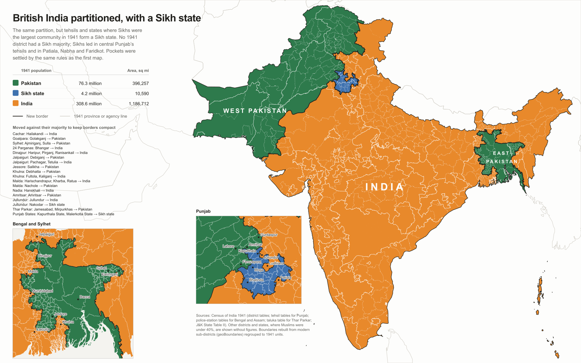
The same partition, with a Sikh state
- Region
- British India, Census 1941
- Data
- The same 1941 data as map 8.
- Rule
- Cells where Sikhs were the largest community become a Sikh state (no 1941 district had a Sikh majority), then the same pocket and compactness rules as map 8 are applied.
No district had a Sikh majority in 1941. Sikhs were the largest community in a band of tehsils across central Punjab (Tarn Taran, Moga, Jagraon, Samrala, Phillaur, Rupar, Kharar) and in most of Patiala, Nabha, Faridkot and Jind’s Sangrur. Carved out of the same partition, they form a state of about 4.2 million people and 10,590 square miles. Kapurthala and Malerkotla States and Nakodar tehsil are added to keep its border compact.
Indus AtlasFree to reuse with credit · CC BY-SA 4.0indusatlas.vercel.app
Hover or tap a district, tehsil or state to see its 1941 Muslim and Sikh shares.
Download PNGFree to reuse with credit. How to credit the atlas
All units
Every unit on the map. Select a row to find it on the plate.
620 units
| 100.0% · – | |
| 100.0% · – | |
| 99.9% · – | |
| 99.7% · 0.1% | |
| 99.7% · 0.1% | |
| 99.7% · 0.1% | |
| 99.7% · 0.1% | |
| 99.7% · – | |
| 99.6% · 0.1% | |
| 99.5% · – | |
| 99.3% · 0.1% | |
| 99.3% · 0.1% | |
| 99.3% · 0.1% | |
| 99.3% · 0.1% | |
| 99.3% · 0.1% | |
| 99.3% · 0.1% | |
| 99.1% · 0.3% | |
| 99.1% · 0.2% | |
| 99.0% · – | |
| 99.0% · – | |
| 98.0% · – | |
| 97.5% · 0.1% | |
| 97.3% · 1.1% | |
| 97.2% · 1.2% | |
| 97.0% · – | |
| 96.9% · 0.3% | |
| 96.8% · 0.0% | |
| 96.7% · 1.3% | |
| 96.0% · – | |
| 95.7% · 0.2% | |
| 95.7% · 0.6% | |
| 95.7% · 1.6% | |
| 95.5% · 2.3% | |
| 95.3% · 0.6% | |
| 95.1% · 2.3% | |
| 94.9% · 1.2% | |
| 94.8% · 0.9% | |
| 94.7% · 0.5% | |
| 94.7% · 1.3% | |
| 93.5% · 0.5% | |
| 93.2% · 2.1% | |
| 92.2% · 2.0% | |
| 92.1% · – | |
| 92.0% · 1.5% | |
| 91.2% · 1.3% | |
| 91.0% · 1.7% | |
| 90.9% · 8.0% | |
| 90.5% · 0.0% | |
| 90.4% · 3.0% | |
| 90.3% · 2.8% |
Sources
- Partition maps: Census of India 1941 district tables (Punjab, NWFP, Sind, Baluchistan, Delhi, Rajputana, J&K via Wikipedia, Pritchett and the 1941 volumes); tehsil tables for Punjab (Vol VI); police-station tables for Bengal (Vol IV) and Assam (Vol IX); taluka table for Thar Parkar (Vol XII).
- British India: geoBoundaries ADM3 for India, Pakistan and Bangladesh, regrouped to 1941 units after the Census of India 1941 and the Imperial Gazetteer of India.