Map 14 · Partition and history
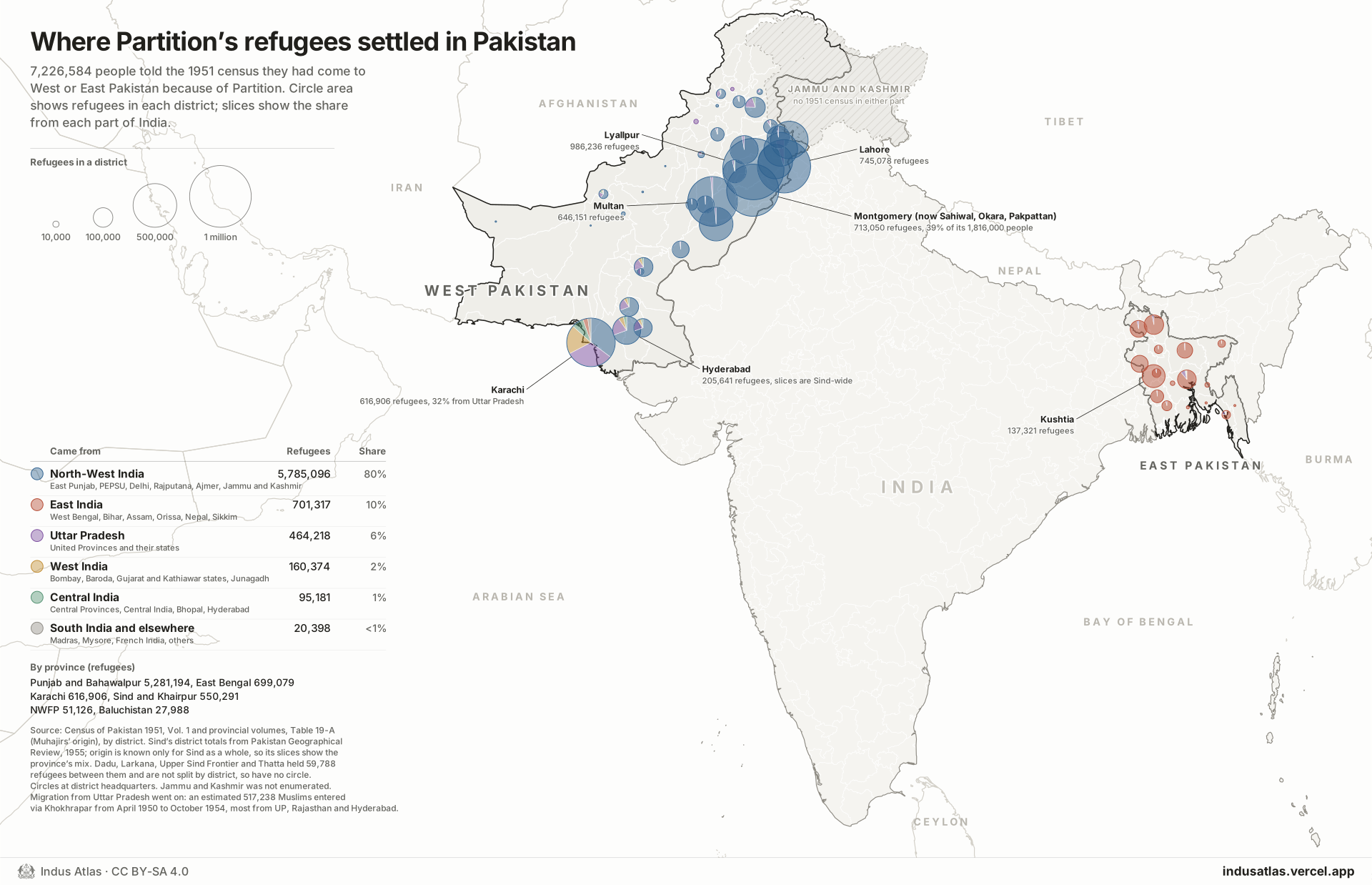
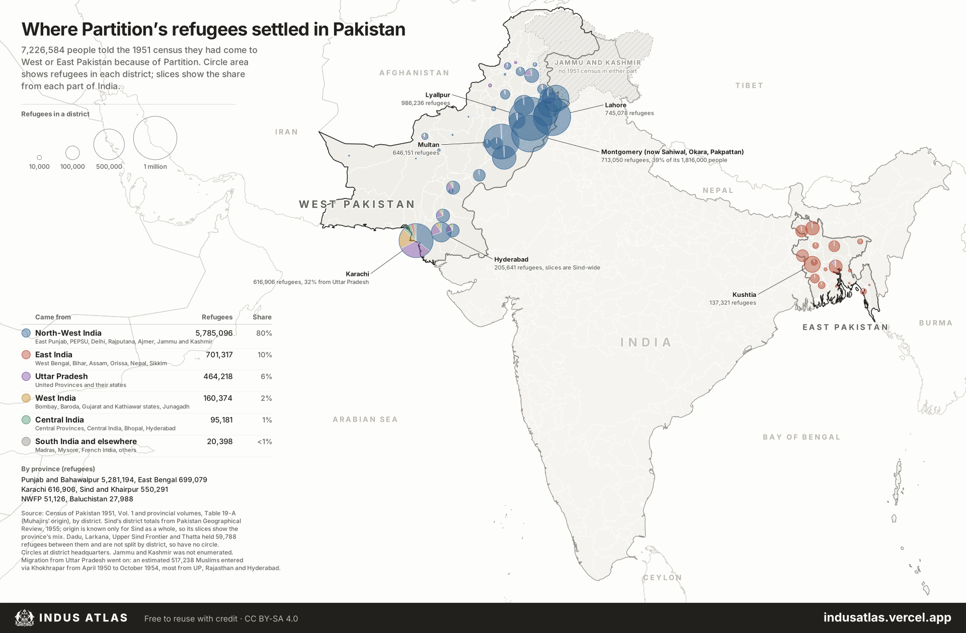
Where Partition’s refugees settled in Pakistan
- Region
- Pakistan, Census 1951
- Data
- Census of Pakistan 1951, Table 19-A, muhajirs by district and zone of origin; Sind’s district totals from a 1955 study.
- Rule
- Circle area is refugees in a district, on the same scale as map 15; each circle is a pie of the zones of India the refugees came from.
The 1951 census of Pakistan asked everyone whether they had come “as a result of Partition or for fear of disturbances connected therewith”. 7,226,584 people said they had, one in ten of the population. Each circle is the number of these muhajirs counted in a district, on the same scale as the India map that follows, drawn as a pie of the zones of India they came from.
Four in five came from North-West India, the Indian Punjab, Delhi and Rajputana, and almost all of them stayed in West Punjab: Lyallpur alone took 986,236, more than all of Sind. Karachi, then the capital, was the exception, with 35% from North-West India, 32% from Uttar Pradesh and 19% from Bombay and Gujarat. In East Bengal 96% of the 699,079 refugees came from East India, mostly West Bengal, Bihar and Assam.
Sind’s census volume could not be found, so its four largest districts come from a 1955 study that quotes their totals, and their pies use the split for Sind as a whole. Its other four districts held 59,788 refugees between them and are not split, so they have no circle. Jammu and Kashmir was not counted in 1951.
Indus AtlasFree to reuse with credit · CC BY-SA 4.0indusatlas.vercel.app
Hover or tap a district to see how many refugees it took and where they came from.
Where they came from
| Came from | Refugees | Share |
|---|---|---|
| North-West India East Punjab, PEPSU, Delhi, Rajputana, Ajmer, Jammu and Kashmir | 5,785,096 | 80% |
| East India West Bengal, Bihar, Assam, Orissa | 701,317 | 10% |
| Uttar Pradesh United Provinces and their states | 464,218 | 6% |
| West India Bombay, Gujarat and Kathiawar states, Junagadh | 160,374 | 2% |
| Central India Central Provinces, Central India, Bhopal, Hyderabad | 95,181 | 1% |
| South India and elsewhere Madras, Mysore, French India, others | 20,398 | <1% |
Districts that took the most
| District | Refugees | NW India | UP | East India |
|---|---|---|---|---|
| Lyallpur Punjab | 986,236 | 99% | 1% | 0% |
| Lahore Punjab | 745,078 | 94% | 5% | 0% |
| Montgomery Punjab | 713,050 | 99% | 0% | 0% |
| Multan Punjab | 646,151 | 99% | 1% | 0% |
| Karachi Karachi | 616,906 | 35% | 32% | 3% |
| Sialkot Punjab | 369,467 | 99% | 1% | 0% |
| Sheikhupura Punjab | 309,890 | 99% | 1% | 0% |
| Gujranwala Punjab | 299,145 | 99% | 1% | 0% |
| Bahawalpur Bahawalpur | 298,140 | 98% | 1% | 0% |
| Shahpur Punjab | 207,256 | 97% | 3% | 0% |
All districts
Every district on the map. Select a row to find it on the plate.
53 districts
| Origin | ||
|---|---|---|
| 986,236 | North-West India 99% | |
| 745,078 | North-West India 94%, Uttar Pradesh 5% | |
| 713,050 | North-West India 99% | |
| 646,151 | North-West India 99%, Uttar Pradesh 1% | |
| 616,906 | North-West India 35%, Uttar Pradesh 32%, West India 19%, Central India 8%, East India 3%, South India 2% | |
| 369,467 | North-West India 99% | |
| 309,890 | North-West India 99% | |
| 299,145 | North-West India 99% | |
| 298,140 | North-West India 98%, Uttar Pradesh 1% | |
| 207,256 | North-West India 97%, Uttar Pradesh 3% | |
| 205,641 | ||
| 138,649 | North-West India 96%, Uttar Pradesh 2%, Central India 1% | |
| 137,321 | East India 99% | |
| 135,676 | North-West India 97%, Uttar Pradesh 2% | |
| 106,262 | North-West India 75%, Uttar Pradesh 20%, Central India 5% | |
| 99,585 | East India 96%, Uttar Pradesh 3% | |
| 93,345 | ||
| 92,739 | ||
| 91,425 | East India 89%, Uttar Pradesh 8%, North-West India 1%, Central India 1%, West India 1% | |
| 88,765 | ||
| 78,559 | North-West India 99%, Uttar Pradesh 1% | |
| 75,900 | East India 99% | |
| 74,726 | North-West India 97%, Uttar Pradesh 2% | |
| 74,379 | East India 96%, Uttar Pradesh 3% | |
| 63,695 | East India 98%, Uttar Pradesh 1% | |
| 52,376 | North-West India 91%, Uttar Pradesh 6%, Central India 2%, East India 2% | |
| 46,672 | North-West India 95%, Uttar Pradesh 3%, Central India 2% | |
| 43,077 | East India 98%, Uttar Pradesh 1% | |
| 38,121 | North-West India 94%, Uttar Pradesh 4%, Central India 2% | |
| 35,740 | North-West India 99%, Uttar Pradesh 1% | |
| 26,059 | East India 96%, Uttar Pradesh 4% | |
| 22,890 | North-West India 61%, Uttar Pradesh 31%, Central India 5%, East India 2%, West India 1% | |
| 21,677 | North-West India 60%, Uttar Pradesh 22%, Central India 10%, West India 6%, South India 1%, East India 1% | |
| 19,933 | East India 97%, Uttar Pradesh 3% | |
| 19,470 | East India 78%, Uttar Pradesh 13%, West India 3%, Central India 2%, North-West India 2%, South India 2% | |
| 18,035 | East India 98%, Uttar Pradesh 2% | |
| 14,219 | East India 96%, Uttar Pradesh 2% | |
| 10,455 | North-West India 76%, Uttar Pradesh 23% | |
| 10,013 | North-West India 50%, Uttar Pradesh 46%, Central India 2% | |
| 7,536 | North-West India 71%, Uttar Pradesh 25%, Central India 3% | |
| 5,821 | East India 88%, Uttar Pradesh 7%, North-West India 4% | |
| 5,319 | Uttar Pradesh 68%, North-West India 32% | |
| 5,317 | East India 98%, Uttar Pradesh 2% | |
| 3,904 | North-West India 49%, Uttar Pradesh 26%, Central India 18%, West India 5% | |
| 3,059 | Uttar Pradesh 51%, North-West India 45%, East India 2%, Central India 1% | |
| 2,418 | East India 94%, Uttar Pradesh 5%, West India 1% | |
| 1,867 | North-West India 58%, Uttar Pradesh 29%, Central India 9%, East India 2%, West India 1% | |
| 1,279 | East India 92%, Uttar Pradesh 3%, Central India 2%, West India 2% | |
| 1,146 | East India 99% | |
| 881 | North-West India 66%, Uttar Pradesh 23%, Central India 9%, West India 1% |
Sources
- Census of Pakistan 1951, Table 19-A, Muhajirs’ origin by district: Vol. 1 (Pakistan), Vol. 2 (Baluchistan), Vol. 3 (East Bengal), Vol. 4 (NWFP), Vol. 5 (Punjab and Bahawalpur State), via the census digital library at censusindia.gov.in.
- Pakistan Geographical Review, 1955, refugee settlement in Sind (district totals of muhajirs from the 1951 census), via the Internet Archive.
- Place names: GeoNames gazetteer for Pakistan, India and Saudi Arabia. Neighbouring countries: Natural Earth.