Map 8 · Partition and history
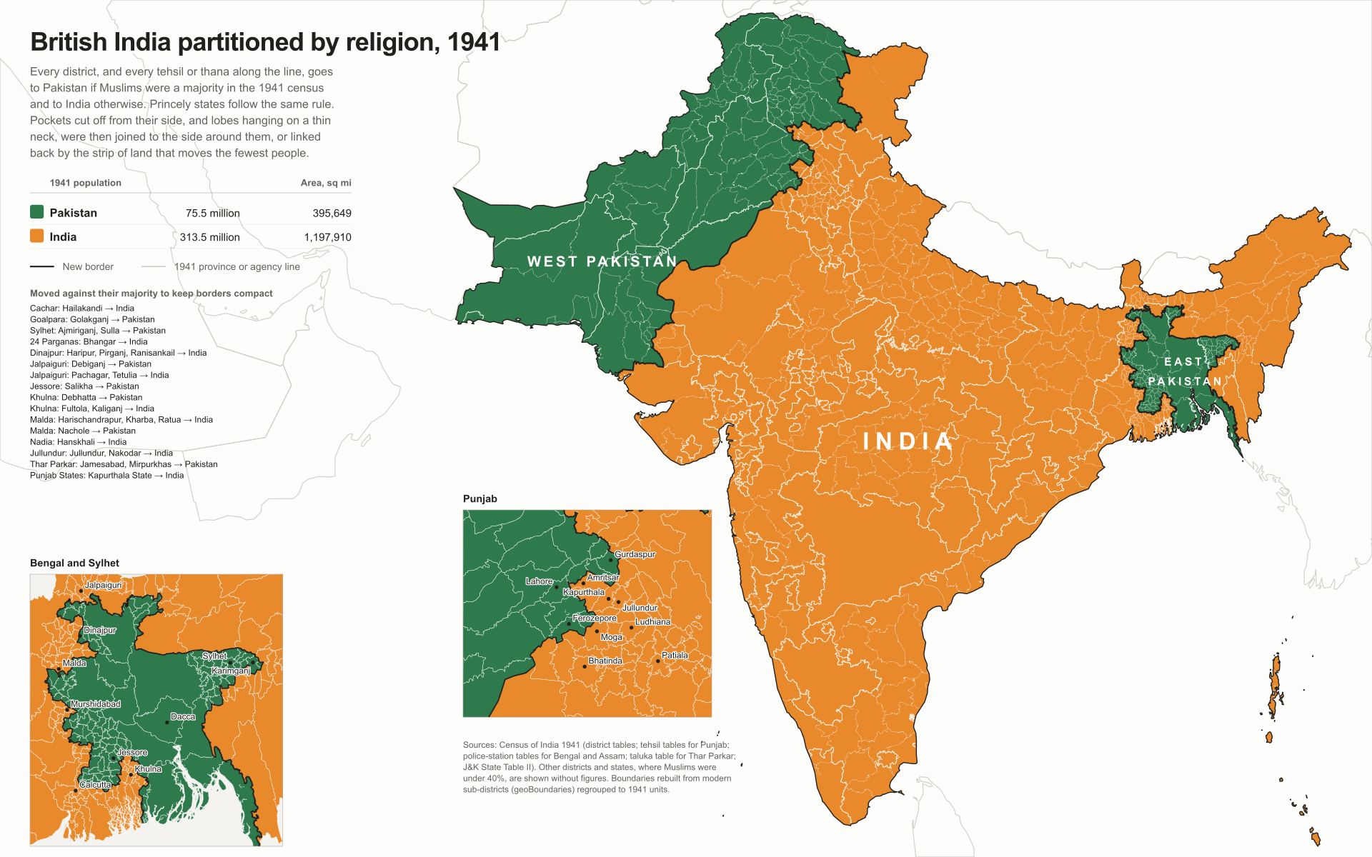
British India partitioned by religion
- Region
- British India, Census 1941
- Data
- 1941 census by district; tehsil tables for the Punjab border, thana tables for Bengal and Assam, taluka table for Thar Parkar.
- Rule
- Pockets cut off from their own side, and lobes hanging on a thin neck, are joined to the side around them, or linked back by the strip of land that moves the fewest people.
Using the 1941 census, the last before independence, every district goes to Pakistan if Muslims were a majority and to India otherwise; princely states follow the same rule. Along the line in Punjab, Bengal, Assam and Thar Parkar the rule is applied tehsil by tehsil and thana by thana, as the boundary commission did, and Jammu & Kashmir district by district. Any pocket cut off from its own country, and any lobe hanging on a thin neck, is then joined to the side around it, or linked back by the strip of land that moves the fewest people.
Indus AtlasFree to reuse with credit · CC BY-SA 4.0indusatlas.vercel.app
Hover or tap a district, tehsil or state to see its 1941 Muslim share.
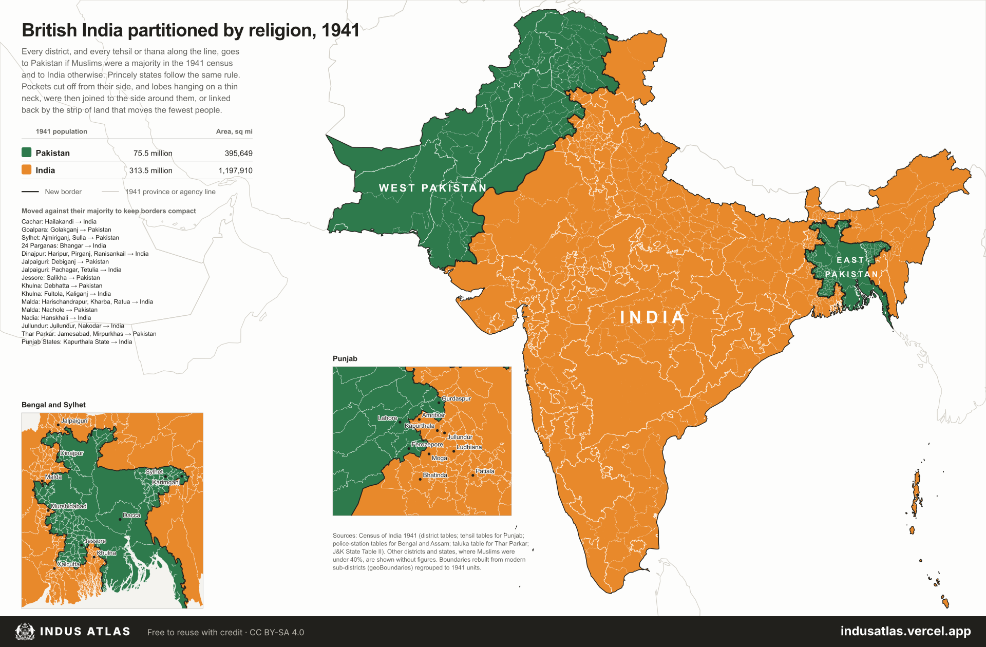
The result is close to 1947 in outline but not in detail. On these figures Pakistan would also have received the Muslim-majority tehsils of Gurdaspur, Batala, Ferozepore and Zira, and Kashmir’s Muslim districts; India keeps Amritsar because Muslim-majority Kapurthala State and the Jullundur and Nakodar tehsils go to India, joining it to the rest of the country. Along the eastern line most of Khulna and the southern 24 Parganas, Hindu-majority by thana, join India, while northern 24 Parganas and much of Nadia and Murshidabad go to East Pakistan. To keep the line compact, Hailakandi in Cachar and several Muslim-majority thanas of Malda, Dinajpur and Jalpaiguri go to India, while Golakganj, Salikha, Debhatta, Nachole, Debiganj and two Sylhet thanas go to Pakistan. In Sind, four Thar Parkar talukas where Muslims were under half, Umarkot among them, join India because they touch Rajputana; Mirpurkhas and Jamesabad, also under half, stay with Pakistan.
All units
Every unit on the map. Select a row to find it on the plate.
620 units
| 100.0% | |
| 100.0% | |
| 99.9% | |
| 99.7% | |
| 99.7% | |
| 99.7% | |
| 99.7% | |
| 99.7% | |
| 99.6% | |
| 99.5% | |
| 99.3% | |
| 99.3% | |
| 99.3% | |
| 99.3% | |
| 99.3% | |
| 99.3% | |
| 99.1% | |
| 99.1% | |
| 99.0% | |
| 99.0% | |
| 98.0% | |
| 97.5% | |
| 97.3% | |
| 97.2% | |
| 97.0% | |
| 96.9% | |
| 96.8% | |
| 96.7% | |
| 96.0% | |
| 95.7% | |
| 95.7% | |
| 95.7% | |
| 95.5% | |
| 95.3% | |
| 95.1% | |
| 94.9% | |
| 94.8% | |
| 94.7% | |
| 94.7% | |
| 93.5% | |
| 93.2% | |
| 92.2% | |
| 92.1% | |
| 92.0% | |
| 91.2% | |
| 91.0% | |
| 90.9% | |
| 90.5% | |
| 90.4% | |
| 90.3% |
Sources
- Partition maps: Census of India 1941 district tables (Punjab, NWFP, Sind, Baluchistan, Delhi, Rajputana, J&K via Wikipedia, Pritchett and the 1941 volumes); tehsil tables for Punjab (Vol VI); police-station tables for Bengal (Vol IV) and Assam (Vol IX); taluka table for Thar Parkar (Vol XII).
- British India: geoBoundaries ADM3 for India, Pakistan and Bangladesh, regrouped to 1941 units after the Census of India 1941 and the Imperial Gazetteer of India.