Census of India 1941, J&K State Table II (tehsil level), shared out to today’s districts.
Rule
1941 is used because it is the last census before partition and covers every part of the state on the same terms.
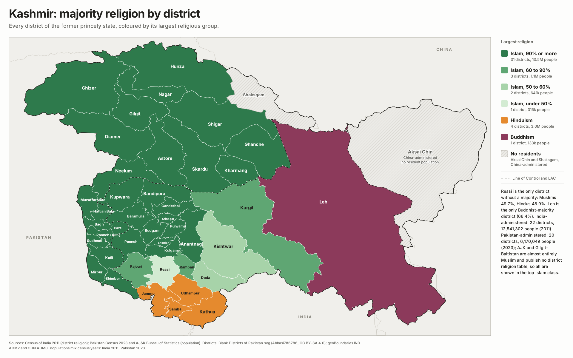
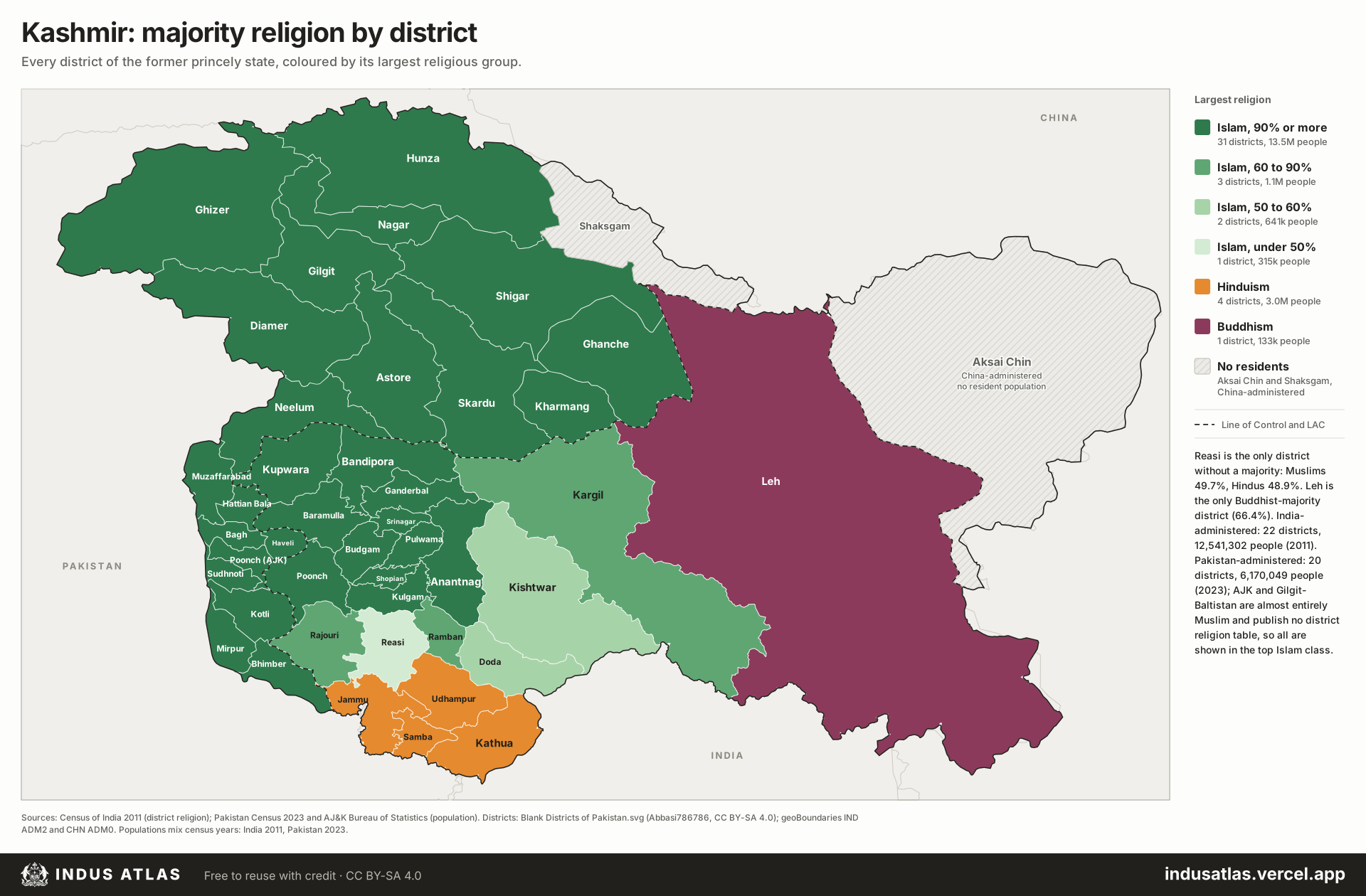
The plates cover the whole of the former princely state: Jammu & Kashmir and Ladakh (India), Azad Jammu & Kashmir and Gilgit-Baltistan (Pakistan), and Aksai Chin and the Shaksgam valley (China). All figures come from the 1941 Census of India, the last count before partition and the only one that covers the whole state on the same terms. It reports religion for every tehsil; each tehsil is placed in the modern district that now covers it, and where today’s lines split a tehsil it is shared out by rough population, so district figures are estimates. In 1941 the census grouped Buddhists under “Others”, which were almost all Buddhists of Ladakh, Zanskar and Paddar. The Chinese-held areas have no resident population; in 1941 Aksai Chin lay within Ladakh tehsil and the Shaksgam valley was Hunza’s pasture, so each takes the colour of that tehsil.
Indus AtlasFree to reuse with credit · CC BY-SA 4.0indusatlas.vercel.app
Hover or tap a district to see its religious composition.
Religion Islam 99.1%; Hinduism 0.5%; Sikhism 0.3%; Other 0.1%1941 tehsils Gilgit Leased Area
22,495
Religion Islam 89.8%; Sikhism 7.0%; Hinduism 3.2%; Other 0.0%1941 tehsils Muzaffarabad (~15%)
18,838
Religion Islam 99.1%; Hinduism 0.7%; Sikhism 0.2%; Other 0.0%1941 tehsils Astore
17,026
Religion Islam 99.7%; Hinduism 0.1%; Sikhism 0.1%; Other 0.0%1941 tehsils Skardu (~15%)
15,941
Religion Islam 99.6%; Hinduism 0.4%; Sikhism 0.1%; Other 0.0%1941 tehsils Chilas
15,364
Religion Islam 100.0%; Sikhism 0.0%1941 tehsils Hunza
15,341
Religion Islam 100.0%1941 tehsils Nagar
14,874
Religion Islam 99.7%; Hinduism 0.1%; Sikhism 0.1%; Other 0.0%1941 tehsils Skardu (~10%)
10,627
Religion No resident population
0
Religion No resident population
0
Sources
Census of India 1941, Vol. XXII, Jammu & Kashmir, Part III, State Table II: population of districts and tehsils by communities (Gokhale Institute digital library). All community totals were checked against the state totals in the table.
District geometry: Blank Districts of Pakistan.svg by Abbasi786786 on Wikimedia Commons (CC BY-SA 4.0); geoBoundaries IND ADM2 (Local Government Directory, 2021) and CHN ADM0, aligned to the Commons map.