Map 3 · Census and identity
Kashmir divided by religion
- Region
- Kashmir, Census 1941
- Data
- Census of India 1941, J&K State Table II, as for map 2.
- Rule
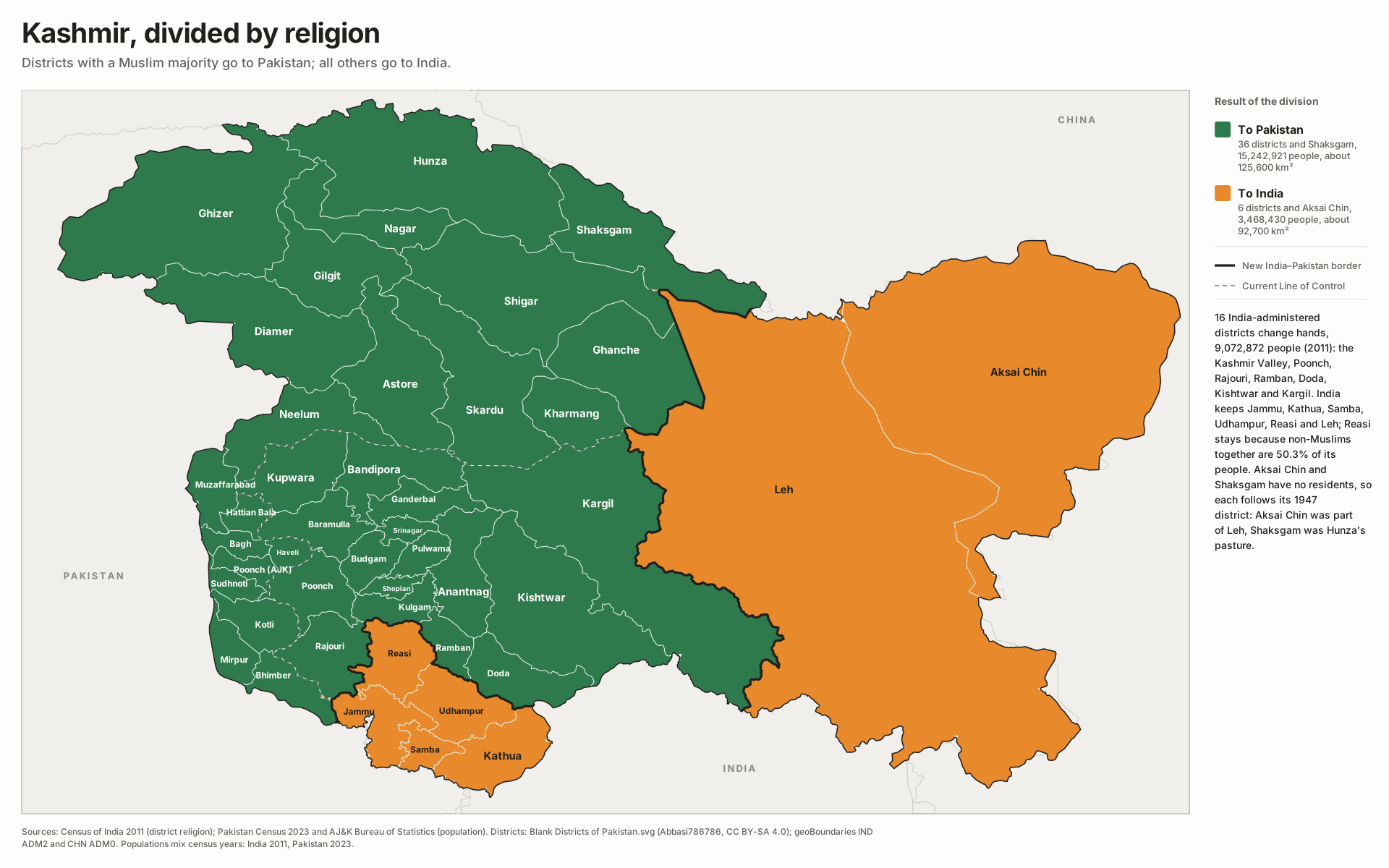
- Muslim majority goes to Pakistan, the rest to India. Aksai Chin follows Leh to India; Shaksgam follows Hunza to Pakistan.
Applying one rule, a Muslim majority in 1941 goes to Pakistan and everything else to India, moves 17 Indian-administered districts and 2,311,947 people (1941 count). India keeps Jammu, Samba, Kathua and Udhampur, Hindu-majority in 1941, and Buddhist Leh. The one change from today’s figures is Reasi: 54.8% Muslim in 1941, just under half in 2011. Doda is the closest call at 50.8%, and depends on how much of the old Kishtwar tehsil is counted with it; below about two-fifths it would stay with India.
China-held land has no residents to count, so each part follows the district it belonged to in 1947. Aksai Chin was part of the Leh tehsil of Ladakh Wazarat, grazed and salt-mined from Ladakh, so it goes with Buddhist-majority Leh to India. The Shaksgam valley was winter pasture for Shimshal herders, and the Mir of Hunza claimed rights there, so it goes with Muslim Hunza to Pakistan.
Indus AtlasFree to reuse with credit · CC BY-SA 4.0indusatlas.vercel.app
Hover or tap a district or territory to see where it would go.
All districts, Census 1941
| District (1941 tehsils) | Territory | 1941 pop. | Largest religion | Muslim | Goes to |
|---|---|---|---|---|---|
| Nagar Nagar | Gilgit-Baltistan | 14,874 | Islam | 100.0% | Pakistan |
| Hunza Hunza | Gilgit-Baltistan | 15,341 | Islam | 100.0% | Pakistan |
| Ghizer Punial, Ishkuman, Yasin, Kuh | Gilgit-Baltistan | 30,947 | Islam | 99.9% | Pakistan |
| Skardu Skardu (~45%) | Gilgit-Baltistan | 47,822 | Islam | 99.7% | Pakistan |
| Ghanche Skardu (~30%) | Gilgit-Baltistan | 31,881 | Islam | 99.7% | Pakistan |
| Shigar Skardu (~15%) | Gilgit-Baltistan | 15,941 | Islam | 99.7% | Pakistan |
| Kharmang Skardu (~10%) | Gilgit-Baltistan | 10,627 | Islam | 99.7% | Pakistan |
| Diamer Chilas | Gilgit-Baltistan | 15,364 | Islam | 99.6% | Pakistan |
| Astore Astore | Gilgit-Baltistan | 17,026 | Islam | 99.1% | Pakistan |
| Gilgit Gilgit Leased Area | Gilgit-Baltistan | 22,495 | Islam | 99.1% | Pakistan |
| Kupwara Handwara (~50%), Karnah | Jammu & Kashmir | 196,334 | Islam | 97.3% | Pakistan |
| Budgam Srinagar Khas (rural) (~20%), Budgam | Jammu & Kashmir | 199,802 | Islam | 97.2% | Pakistan |
| Ganderbal Srinagar Khas (rural) (~50%) | Jammu & Kashmir | 63,047 | Islam | 96.9% | Pakistan |
| Bandipora Handwara (~25%) | Jammu & Kashmir | 68,736 | Islam | 96.7% | Pakistan |
| Pulwama Awantipura (~85%) | Jammu & Kashmir | 133,047 | Islam | 95.7% | Pakistan |
| Shopian Awantipura (~15%), Kulgam (~40%) | Jammu & Kashmir | 86,428 | Islam | 95.7% | Pakistan |
| Kulgam Kulgam (~60%) | Jammu & Kashmir | 94,423 | Islam | 95.7% | Pakistan |
| Baramulla Baramulla, Uri, Handwara (~25%) | Jammu & Kashmir | 311,862 | Islam | 95.1% | Pakistan |
| Poonch Mendhar, Haveli (~60%) | Jammu & Kashmir | 168,140 | Islam | 94.8% | Pakistan |
| Anantnag Anantnag | Jammu & Kashmir | 203,827 | Islam | 94.7% | Pakistan |
| Haveli Haveli (~40%) | Azad Jammu & Kashmir | 44,297 | Islam | 93.2% | Pakistan |
| Mirpur Mirpur | Azad Jammu & Kashmir | 113,203 | Islam | 92.2% | Pakistan |
| Kotli Kotli | Azad Jammu & Kashmir | 111,037 | Islam | 91.2% | Pakistan |
| Bagh Bagh (~80%) | Azad Jammu & Kashmir | 80,873 | Islam | 90.9% | Pakistan |
| Muzaffarabad Muzaffarabad (~60%) | Azad Jammu & Kashmir | 75,351 | Islam | 89.8% | Pakistan |
| Hattian Bala Muzaffarabad (~25%) | Azad Jammu & Kashmir | 31,396 | Islam | 89.8% | Pakistan |
| Neelum Muzaffarabad (~15%) | Azad Jammu & Kashmir | 18,838 | Islam | 89.8% | Pakistan |
| Poonch (AJK) Bagh (~20%), Sudhnoti (~50%) | Azad Jammu & Kashmir | 74,368 | Islam | 85.3% | Pakistan |
| Kargil Kargil | Ladakh | 52,853 | Islam | 84.0% | Pakistan |
| Sudhnoti Sudhnoti (~50%) | Azad Jammu & Kashmir | 54,150 | Islam | 83.2% | Pakistan |
| Srinagar Srinagar city, Srinagar Khas (rural) (~30%) | Jammu & Kashmir | 245,615 | Islam | 81.3% | Pakistan |
| Rajouri Rajouri, Bhimbar (~30%) | Jammu & Kashmir | 189,568 | Islam | 75.4% | Pakistan |
| Ramban Ramban | Jammu & Kashmir | 75,796 | Islam | 70.8% | Pakistan |
| Bhimber Bhimbar (~70%) | Azad Jammu & Kashmir | 113,690 | Islam | 64.8% | Pakistan |
| Kishtwar Kishtwar (~50%) | Jammu & Kashmir | 30,446 | Islam | 58.0% | Pakistan |
| Reasi Reasi | Jammu & Kashmir | 117,059 | Islam | 54.8% | Pakistan |
| Doda Bhadrawah, Kishtwar (~50%) | Jammu & Kashmir | 74,964 | Islam | 50.8% | Pakistan |
| Samba Samba | Jammu & Kashmir | 90,464 | Hinduism | 39.7% | India |
| Jammu Jammu, R.S. Pura, Akhnur | Jammu & Kashmir | 340,898 | Hinduism | 39.6% | India |
| Kathua Kathua, Jasmergarh (Hiranagar), Basohli | Jammu & Kashmir | 177,672 | Hinduism | 25.4% | India |
| Udhampur Udhampur, Ramnagar, Chenani | Jammu & Kashmir | 124,806 | Hinduism | 16.9% | India |
| Leh Ladakh (Leh) | Ladakh | 36,307 | Buddhism | 11.3% | India |
All 20 Pakistan-administered districts were Muslim-majority in 1941 and stay with Pakistan. Bhimber was the least Muslim of them at 65%, with a large Hindu and Sikh population around Bhimber and Naushera.
All districts
Every district on the map. Select a row to find it on the plate.
44 districts
| 340,898 | |
| 311,862 | |
| 245,615 | |
| 203,827 | |
| 199,802 | |
| 196,334 | |
| 189,568 | |
| 177,672 | |
| 168,140 | |
| 133,047 | |
| 124,806 | |
| 117,059 | |
| 113,690 | |
| 113,203 | |
| 111,037 | |
| 94,423 | |
| 90,464 | |
| 86,428 | |
| 80,873 | |
| 75,796 | |
| 75,351 | |
| 74,964 | |
| 74,368 | |
| 68,736 | |
| 63,047 | |
| 54,150 | |
| 52,853 | |
| 47,822 | |
| 44,297 | |
| 36,307 | |
| 31,881 | |
| 31,396 | |
| 30,947 | |
| 30,446 | |
| 22,495 | |
| 18,838 | |
| 17,026 | |
| 15,941 | |
| 15,364 | |
| 15,341 | |
| 14,874 | |
| 10,627 | |
| 0 | |
| 0 |
Sources
- Census of India 1941, Vol. XXII, Jammu & Kashmir, Part III, State Table II: population of districts and tehsils by communities (Gokhale Institute digital library). All community totals were checked against the state totals in the table.
- District geometry: Blank Districts of Pakistan.svg by Abbasi786786 on Wikimedia Commons (CC BY-SA 4.0); geoBoundaries IND ADM2 (Local Government Directory, 2021) and CHN ADM0, aligned to the Commons map.