Map 1 · Census and identity
Pakistan by mother tongue
- Region
- Pakistan, Census 2023
- Data
- Pakistan Census 2023, Table 11 (mother tongue) for 156 districts; AJK and GB from their bureau figures.
- Rule
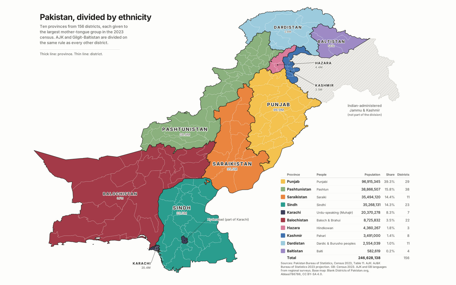
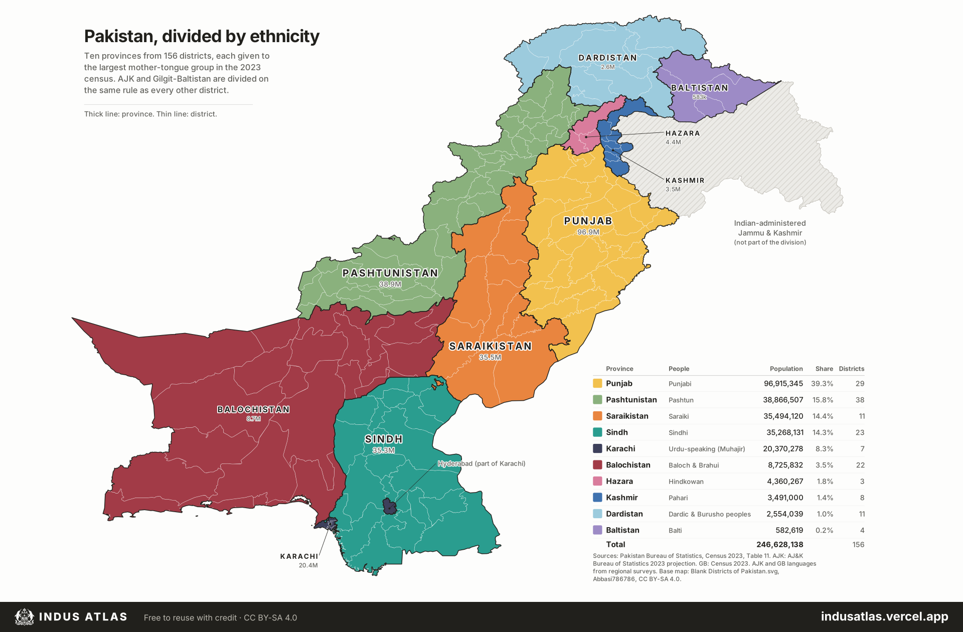
- Each district goes to its largest mother-tongue group. AJK and GB are divided like any other district. Keamari goes with Karachi; Mirpur and Bhimber (Pothwari) join Punjab.
Each of 156 districts goes to the group with the largest mother-tongue share in the 2023 census. Azad Jammu & Kashmir and Gilgit-Baltistan are treated like every other district. Ten provinces result; Punjab alone holds 39% of the population.
Indus AtlasFree to reuse with credit · CC BY-SA 4.0indusatlas.vercel.app
Hover or tap a district to see its population and leading languages.
Download PNGFree to reuse with credit. How to credit the atlas
| Province | People | Main language | Population | Share | Districts |
|---|---|---|---|---|---|
| Punjab | Punjabi | Punjabi | 96,915,345 | 39.3% | 29 |
| Pashtunistan | Pashtun | Pashto | 38,866,507 | 15.8% | 38 |
| Saraikistan | Saraiki | Saraiki | 35,494,120 | 14.4% | 11 |
| Sindh | Sindhi | Sindhi | 35,268,131 | 14.3% | 23 |
| Karachi | Urdu-speaking (Muhajir) | Urdu | 20,370,278 | 8.3% | 7 |
| Balochistan | Baloch & Brahui | Balochi, Brahui | 8,725,832 | 3.5% | 22 |
| Hazara | Hindkowan | Hindko | 4,360,267 | 1.8% | 3 |
| Kashmir | Pahari | Pahari, Gojri, Kashmiri | 3,491,000 | 1.4% | 8 |
| Dardistan | Dardic & Burusho peoples | Shina, Khowar, Kohistani, Burushaski | 2,554,039 | 1.0% | 11 |
| Baltistan | Balti | Balti | 582,619 | 0.2% | 4 |
| Total | 246,628,138 | 100% | 156 |
Decisions behind the lines
- Balochi and Brahui speakers form one Balochistan; Brahuis largely identify as Baloch, and splitting them would leave a Brahui island in Kalat, Khuzdar, Mastung, Surab and Nushki.
- Dardistan joins the northern mountain peoples: Shina, Khowar (the census “others” in Chitral), Kohistani and Burushaski. Each alone is too small to stand as a province.
- Pahari-Pothwari is a dialect chain of Western Punjabi, not one block. Mirpur and Bhimber speak the Pothohar-plateau form, the same speech the census records as Punjabi next door in Jhelum and Rawalpindi, so on the census’s own rule they join Punjab. Kotli and the districts to the north speak the distinct Pahari (Poonchi, Chibhali) dialects and form Kashmir. Mirpuris themselves hold a strong Kashmiri identity, so an identity-based map would keep them in Kashmir.
- Hyderabad (Urdu 45.9%, Sindhi 43.1%) is a Karachi exclave by strict plurality. Keamari has a Pashto plurality (33.1%) but is part of Karachi city and is grouped with it.
- AJK and Gilgit-Baltistan have no published 2023 mother-tongue table. Their populations come from the AJ&K Bureau of Statistics (2023 projection) and the 2023 census; their languages from district-level surveys.
All districts
Every district on the map. Select a row to find it on the plate.
156 districts
| 12,978,661 | |
| 9,065,306 | |
| 6,058,540 | |
| 5,940,173 | |
| 5,561,720 | |
| 5,340,762 | |
| 5,012,124 | |
| 4,750,388 | |
| 4,472,462 | |
| 4,327,263 | |
| 4,264,457 | |
| 4,081,568 | |
| 4,049,377 | |
| 3,913,656 | |
| 3,820,388 | |
| 3,544,911 | |
| 3,503,451 | |
| 3,428,191 | |
| 3,386,575 | |
| 3,363,589 | |
| 3,216,000 | |
| 3,127,976 | |
| 3,065,639 | |
| 2,878,122 | |
| 2,740,692 | |
| 2,686,076 | |
| 2,679,380 | |
| 2,597,448 | |
| 2,524,044 | |
| 2,432,540 | |
| 2,419,736 | |
| 2,329,764 | |
| 2,323,980 | |
| 2,307,831 | |
| 2,283,244 | |
| 2,271,290 | |
| 2,135,511 | |
| 2,133,005 | |
| 2,102,361 | |
| 2,066,574 | |
| 1,956,971 | |
| 1,950,769 | |
| 1,945,417 | |
| 1,926,357 | |
| 1,890,230 | |
| 1,844,627 | |
| 1,835,136 | |
| 1,829,152 | |
| 1,822,916 | |
| 1,795,897 |
Sources
- Pakistan Bureau of Statistics, Census 2023, Table 11: population by mother tongue, district-wise tables for all four provinces and Islamabad.
- AJ&K Planning & Development, AJK at a Glance 2024 (district populations, 2023 projection); GB Planning & Development, GB at a Glance 2025 (Census 2023 district populations).
- District geometry: Blank Districts of Pakistan.svg by Abbasi786786 on Wikimedia Commons (CC BY-SA 4.0); geoBoundaries IND ADM2 (Local Government Directory, 2021) and CHN ADM0, aligned to the Commons map.