UNODC Afghanistan Opium Survey province tables for every year from 1994 to 2025.
Rule
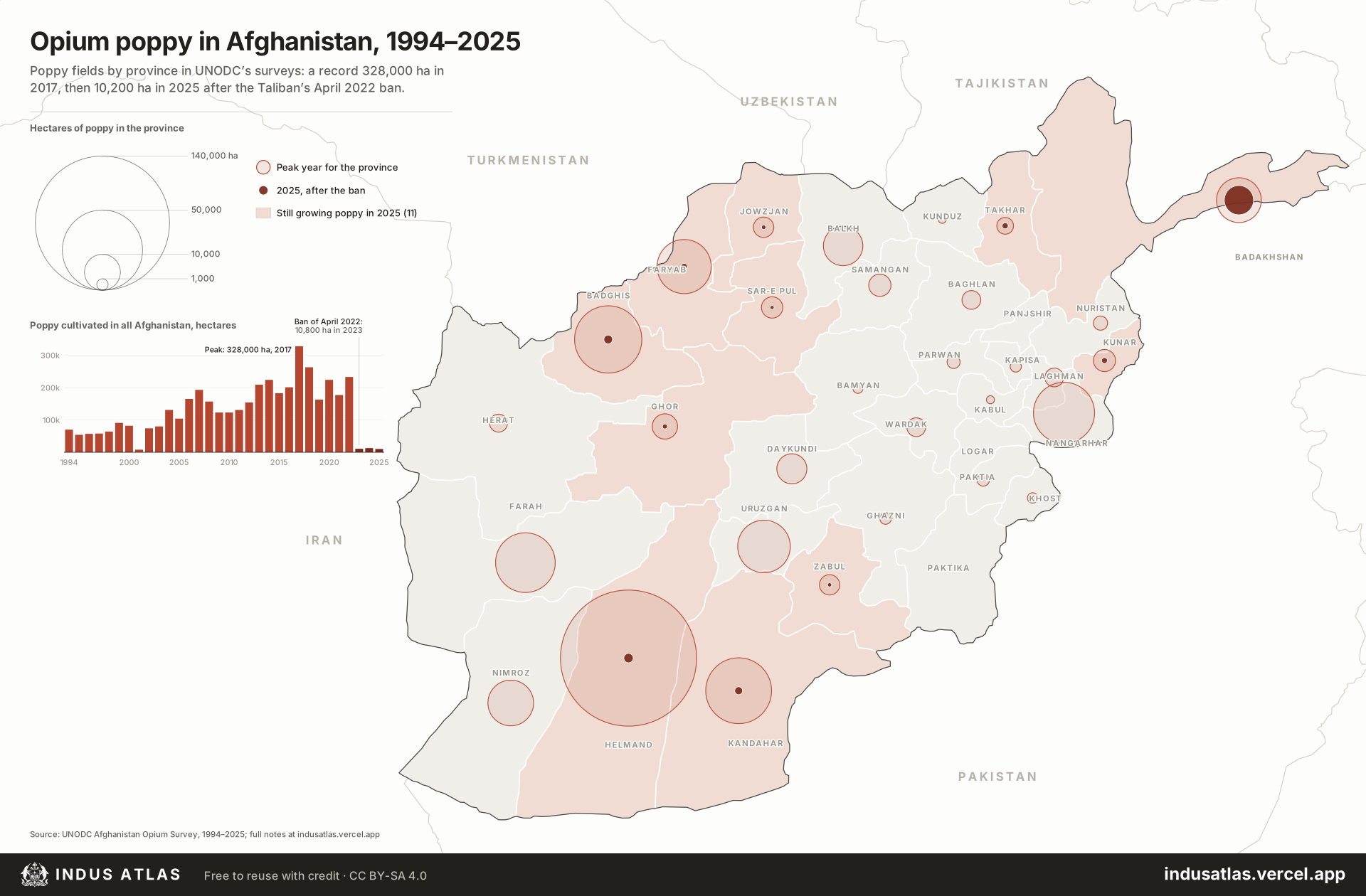
Open circles are each province’s peak year and solid circles 2025, by area; tinted provinces still grew poppy in 2025.
Afghanistan grew most of the world’s illicit opium for three decades. UNODC’s yearly surveys measured 70,000 hectares of opium poppy in 1994, mostly in Helmand and Nangarhar. The first Taliban ban, decreed in July 2000, cut the 2001 crop to 8,000 hectares, nearly all of it in Badakhshan, which the Taliban did not control. After 2001 cultivation spread to almost every province, then concentrated in the south and west: Helmand alone grew 144,018 hectares in 2017, when the national total reached a record 328,000. In April 2022 the Taliban banned poppy again. The 2022 harvest, 233,000 hectares, was largely spared, but in 2023 fields fell to 10,800 hectares, and in 2025 to 10,200, with 23 of the 34 provinces poppy-free. What remains is mostly in Badakhshan (6,639 hectares in 2025). Open circles show each province’s peak year and solid circles 2025; the chart shows the national total each year.
Indus AtlasFree to reuse with credit · CC BY-SA 4.0indusatlas.vercel.app
Hectares are the area left standing at harvest, after any eradication, as UNODC estimates it. Before 2002 the surveys were village ground surveys; from 2002 they combine satellite images with field checks, so early figures are less precise.
Province figures for 1994–2006 are UNODC’s revised series from the 2009 survey, which splits Daykundi from Uruzgan back to 1994; earlier reports printed slightly different figures for some provinces. Later figures are from the most recent survey that printed each year.
Boundary changes move some fields between provinces: Gizab district passed from Daykundi to Uruzgan in 2014, and a boundary change around Dilaram makes Farah and Nimroz before 2013 not strictly comparable with later years.
National totals are UNODC’s rounded figures; province rows can add up to a few hundred hectares more or less.
All provinces
Every province on the map. Select a row to find it on the plate.
34 provinces
2022
2025
144,018
122,045
681
35,234
14,110
573
33,713
29,229
481
29,081
5,241
Poppy-free
27,733
15,829
Poppy-free
22,797
6,929
304
21,541
14,557
Poppy-free
16,252
2,429
Poppy-free
15,607
4,305
6,639
12,116
4,542
Poppy-free
7,044
837
Poppy-free
4,983
1,784
183
3,874
132
Poppy-free
3,795
822
252
3,550
3,454
116
3,237
1,359
146
3,211
1,531
132
2,756
1,102
Poppy-free
2,742
615
Poppy-free
2,735
Poppy-free
Poppy-free
2,531
1,337
Poppy-free
2,179
Poppy-free
274
1,554
Poppy-free
Poppy-free
1,310
Poppy-free
Poppy-free
1,200
Poppy-free
Poppy-free
1,027
163
Poppy-free
968
184
Poppy-free
838
Poppy-free
Poppy-free
803
Poppy-free
Poppy-free
500
216
Poppy-free
489
Poppy-free
Poppy-free
0
Poppy-free
Poppy-free
0
Poppy-free
Poppy-free
0
Poppy-free
Poppy-free
Sources
UNODC (UNDCP before 2002), Afghanistan Opium Survey: the 2009 survey’s province series for 1994–2006 (ground surveys, revised), and the 2011, 2014, 2016, 2018, 2021, 2023 and 2025 surveys for 2007–2025 (satellite imagery), unodc.org/unodc/en/crop-monitoring. Copies of the 2005 and 2007 surveys used for checks; 2024 from Afghanistan Drug Insights vol. 1.
Afghanistan: geoBoundaries AFG ADM1 (34 provinces); neighbouring countries from Natural Earth.