Site name, district, phases, dating, size, description, survey and how precisely the position is known, for every placed site.
Rule
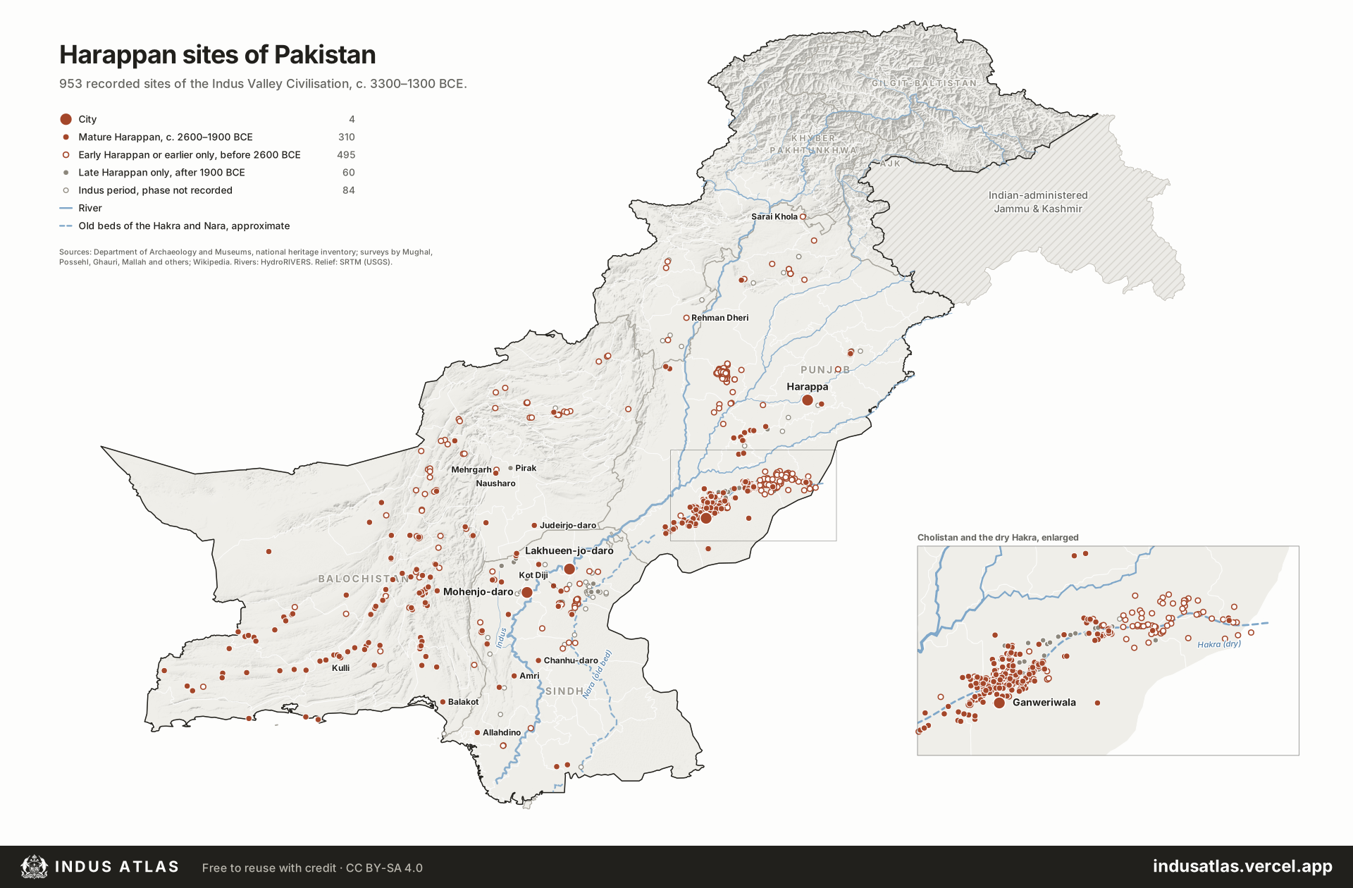
Large circles are the four cities; solid terracotta circles are Mature Harappan sites, hollow ones Early Harappan or earlier only, grey ones Late Harappan only, and small grey rings sites whose phase is not recorded. The dashed blue line is the approximate old bed of the Hakra and Nara.
Pakistan holds most of the Indus Valley, or Harappan, Civilisation: three of the five cities usually counted as its largest, Mohenjo-daro, Harappa and Ganweriwala, the more recently found city of Lakhueen-jo-daro near Sukkur, and more than a thousand smaller towns, villages and camps recorded by surveys since the 1920s. The map shows 953 sites with a known position, 314 of them occupied in the Mature Harappan period (c. 2600–1900 BCE). They follow water: the Indus and its Punjab tributaries, the piedmont of the Kirthar and Sulaiman ranges, the river valleys of Balochistan and the Makran coast, and above all the dry bed of the Hakra in Cholistan, where more than 350 sites line a river that no longer flows.
Most positions come from the national heritage inventory of the Department of Archaeology and Museums, which records each site with its coordinates, the survey that found it and a short description. Sites the inventory lacks, such as Kot Diji, Allahdino and Pir Shah Jurio, were added from Wikipedia, Wikidata and published surveys. Each site is coloured by the latest phase its description names; many survey records give only “3500–1800 BCE”, shown as phase not recorded.
Indus AtlasFree to reuse with credit · CC BY-SA 4.0indusatlas.vercel.app
The Indus Valley Civilisation, also called the Harappan Civilisation after the first of its cities to be excavated, was one of the three earliest urban civilisations of the Old World, alongside Mesopotamia and Egypt. It was also the largest of the three: its sites spread across some 800,000 km², from the Makran coast to the upper Ganges and from northern Afghanistan to Gujarat. The greater part of that area lies in what is now Pakistan.
It grew over three broad stages. In the Early Harappan period (c. 3300–2600 BCE), farming villages in the Indus plain and the Balochistan valleys built walled towns and traded across the region, with regional styles named Hakra, Kot Diji, Amri and Nal. In the Mature Harappan period (c. 2600–1900 BCE), these merged into one urban culture with planned cities, standard weights, a shared script and common styles of pottery, seals and brick. In the Late Harappan period (c. 1900–1300 BCE), the cities emptied and life went on in smaller, more local settlements such as those of the Jhukar and Cemetery H cultures.
Cities and daily life
Mohenjo-daro in Sindh, a World Heritage Site since 1980, is the best preserved Mature Harappan city. It stands on a raised citadel and a lower town laid out in blocks, built of baked brick of uniform proportions, with wells, bathing platforms, covered street drains and the Great Bath. Harappa on the old course of the Ravi was occupied for about two thousand years. Ganweriwala in Cholistan and Lakhueen-jo-daro near Sukkur are of a similar size, but have hardly been excavated.
Harappans grew wheat, barley and cotton, kept cattle, and made carnelian beads, shell bangles, copper tools and stamp seals carved with animals and short inscriptions. Their goods reached Mesopotamia, where texts name a land called Meluhha that is generally taken to be the Indus. The script, known from several thousand short inscriptions, has not been deciphered, so the names of the cities and of their rulers, if they had any, are unknown.
Decline
From about 1900 BCE the large cities were abandoned over a few centuries. The usual explanation is a combination of a weaker monsoon and shifting rivers. The Hakra, which once flowed through Cholistan, dried up, and the dense line of sites along its bed in Bahawalpur district is the clearest sign on this map of a landscape that has since changed. No evidence supports the older idea of a sudden invasion.
Reading the map
Each dot is one recorded site, coloured by the latest Harappan phase its record names: solid terracotta for Mature Harappan, a hollow ring for Early Harappan and the farming villages that led into it, grey for Late Harappan, and a small grey ring where the survey gives only a broad date. The four largest cities are marked with a larger symbol and named. The dashed line traces the dry beds of the Hakra and the Nara. The inset enlarges Cholistan, where the sites are too dense to read at the scale of the whole country. Select a site for its name, phase, district, the survey that recorded it and how precise its position is.
Sites by province and phase
Province
Cities
Mature Harappan
Early Harappan or earlier only
Late Harappan only
Phase not recorded
All
Punjab
2
188
390
49
30
659
Balochistan
0
101
59
1
2
163
Sindh
2
21
42
10
46
121
Khyber Pakhtunkhwa
0
0
4
0
6
10
Pakistan
4
310
495
60
84
953
The districts with the most sites
District
Province
Sites
Bahawalpur
Punjab
337
Layyah
Punjab
219
Khairpur
Sindh
49
Khuzdar
Balochistan
42
Rahim Yar Khan
Punjab
30
Sukkur
Sindh
27
Awaran
Balochistan
20
Loralai
Balochistan
16
How precise the positions are
How the position is known
Sites
Surveyed position of the site
619
Position shared with other listed sites (approximate)
225
Position given to the nearest minute (about 1.5 km)
92
Unverified: the inventory names a district far from this position
13
Approximate
3
Placed at the nearest village
1
Phases follow the inventory’s descriptions (“associated with Hakra phase”, “Early and Mature Harappan”). Hakra, Kot Diji, Amri, Nal, Damb Sadaat and Sothi material count as Early Harappan; Kulli and Sorath as Mature Harappan, the Kulli culture being the Mature Harappan of southern Balochistan; Jhukar, Pirak and Cemetery H as Late Harappan. A site counts as Mature Harappan if any Mature occupation is named.
The inventory files every Bronze Age site in Balochistan under Indus Civilization. Only the 163 Balochistan sites whose records name a Harappan-linked culture (Harappan, Kulli, Nal, Amri, Kot Diji, Damb Sadaat) are shown; 128 that name only Kechi Beg, Togau or a bare sherd scatter, mostly in Makran, are left out. Mehrgarh, Kili Ghul Muhammad, Rana Ghundai, Anjira and Sheri Khan Tarakai are earlier farming villages whose later levels lead into the Early Harappan, and are shown with it.
The dashed line in Sindh is the Nara, the old lower course of the Hakra, traced by HydroRIVERS down the terrain to the Rann of Kutch; parts of it now carry the Nara Canal from the Sukkur barrage. The Hakra’s dry bed in Cholistan is drawn through the line of Cholistan sites and the forts of Fort Abbas, Marot and Derawar that stand on it. It is approximate; terrain models route the lowest ground 15 to 25 km further south.
Positions: about two-thirds of sites carry surveyed coordinates. Others are given to the nearest minute (about 1.5 km), or share one point with neighbouring sites (often several mounds at one village, from Possehl’s gazetteer). For 13 sites the inventory names a district far from its coordinates; they are kept and marked unverified. Known misprints were corrected: Amri, Pirak, Miri Qalat, Quetta Miri and Mughal Ghundai.
Named in surveys but without a position, and so not on the map (38): Bagro (Sindh), Bhirwala (Punjab), Bistoi Bhit (Sindh), Chak 21-M (Punjab), Chak 27-M (Punjab), Chak Purbane Syal (Punjab), Charoyanwala (Punjab), Dabarkot (Balochistan), Gachero jo daro (Sindh), Garh Tor (Sindh), Garhari (Sindh), Gathan Wari Bhit (Sindh), Goth Taro (Sindh), Hakroi (Sindh), Hangorji Bhit (Sindh), Jari goth (Sindh), Kath garh (Kathgarh Thikratho) (Sindh), Khaman waro daro (Sindh), Khandi Bhit (Sindh), Kot Kori (Sindh), Kulloi (Balochistan), Kurinjri Jo Kot (Sindh), Lakhomir-ji-Mari (Sindh), Lewan (Khyber Pakhtunkhwa), Lubanko Tor (Sindh), Lundro jo daro (Sindh), Mamro Bhit (Sindh), Marijo (Sindh), Markhan (Sindh), Maro Waro Dhoro (Sindh), Ongar (Sindh), Sahte jo Goth (Sindh), Serahko Bhit (Sindh), Setharo jo Daro (Sindh), Sunkewala (Punjab), Sur Jangal (Balochistan), Tharo jo daro (Sindh), Wattoowala (Punjab).
All sites
Every site on the map. Select a row to find it on the plate.
953 sites
District
Phases
City
Sahiwal, Punjab
Early Harappan; Mature Harappan; Late Harappan
City
Qambar Shahdadkot, Sindh
Mature Harappan
City
Sukkur, Sindh
Mature Harappan
City
Bahawalpur, Punjab
Mature Harappan
Mature Harappan site
Awaran, Balochistan
Mature Harappan
Mature Harappan site
Awaran, Balochistan
Early Harappan; Mature Harappan
Mature Harappan site
Awaran, Balochistan
Early Harappan; Mature Harappan
Mature Harappan site
Awaran, Balochistan
Early Harappan; Mature Harappan
Mature Harappan site
Awaran, Balochistan
Early Harappan; Mature Harappan
Mature Harappan site
Awaran, Balochistan
Early Harappan; Mature Harappan
Mature Harappan site
Awaran, Balochistan
Early Harappan; Mature Harappan
Mature Harappan site
Awaran, Balochistan
Mature Harappan
Mature Harappan site
Awaran, Balochistan
Early Harappan; Mature Harappan
Mature Harappan site
Awaran, Balochistan
Early Harappan; Mature Harappan
Mature Harappan site
Awaran, Balochistan
Mature Harappan
Mature Harappan site
Awaran, Balochistan
Mature Harappan
Mature Harappan site
Awaran, Balochistan
Mature Harappan
Mature Harappan site
Awaran, Balochistan
Mature Harappan
Mature Harappan site
Awaran, Balochistan
Mature Harappan
Mature Harappan site
Awaran, Balochistan
Mature Harappan
Mature Harappan site
Awaran, Balochistan
Early Harappan; Mature Harappan; Late Harappan
Mature Harappan site
Awaran, Balochistan
Early Harappan; Mature Harappan
Mature Harappan site
Gwadar, Balochistan
Early Harappan; Mature Harappan
Mature Harappan site
Gwadar, Balochistan
Mature Harappan
Mature Harappan site
Gwadar, Balochistan
Early Harappan; Mature Harappan
Mature Harappan site
Jhal Magsi, Balochistan
Mature Harappan; Late Harappan
Mature Harappan site
Jhal Magsi, Balochistan
Mature Harappan
Mature Harappan site
Jhal Magsi, Balochistan
Mature Harappan
Mature Harappan site
Kachhi, Balochistan
Early Harappan; Mature Harappan; Late Harappan
Mature Harappan site
Kalat, Balochistan
Mature Harappan
Mature Harappan site
Kalat, Balochistan
Mature Harappan
Mature Harappan site
Kalat, Balochistan
Mature Harappan
Mature Harappan site
Kech, Balochistan
Mature Harappan
Mature Harappan site
Kech, Balochistan
Mature Harappan
Mature Harappan site
Kech, Balochistan
Early Harappan; Mature Harappan
Mature Harappan site
Kech, Balochistan
Mature Harappan
Mature Harappan site
Kech, Balochistan
Mature Harappan
Mature Harappan site
Kech, Balochistan
Early Harappan; Mature Harappan
Mature Harappan site
Kech, Balochistan
Early Harappan; Mature Harappan
Mature Harappan site
Kech, Balochistan
Mature Harappan
Mature Harappan site
Kech, Balochistan
Mature Harappan
Mature Harappan site
Kech, Balochistan
Mature Harappan
Mature Harappan site
Kharan, Balochistan
Mature Harappan
Mature Harappan site
Kharan, Balochistan
Mature Harappan
Mature Harappan site
Kharan, Balochistan
Mature Harappan
Mature Harappan site
Kharan, Balochistan
Early Harappan; Mature Harappan
Mature Harappan site
Kharan, Balochistan
Mature Harappan
Mature Harappan site
Kharan, Balochistan
Early Harappan; Mature Harappan
Mature Harappan site
Kharan, Balochistan
Early Harappan; Mature Harappan
Mature Harappan site
Khuzdar, Balochistan
Mature Harappan
Sources
Indus Valley Civilisation sites: Department of Archaeology and Museums, Government of Pakistan, national heritage inventory (doam.gov.pk), Bronze Age–Indus Civilization records with their surveys: M. R. Mughal, Ancient Cholistan survey (1974–77); G. L. Possehl, Indus Age: The Beginnings; Z. S. Ghauri, Thal survey; N. Rasool, surveyed districts of Punjab; R. Besenval and P. Sanlaville, Makran; Q. H. Mallah, Hakra and Sindh surveys; and others, read October 2026.
Further sites and corrections: Wikipedia and Wikidata site articles (Kot Diji, Amri, Pirak, Allahdino, Pir Shah Jurio, Miri Qalat, Sutkagen Dor, Hathial), P. Biagi, Lower Sindh survey (2010), and A. Dogar and M. Sadique, Cholistan survey table, Ancient Punjab 10 (2022).
Rivers: HydroSHEDS HydroRIVERS v1.0, mean flow 40 m³/s or more. Relief: SRTM (USGS) via AWS Terrain Tiles.